

2004 Indian Ocean Tsunami and Earthquake
third largest earthquake ever recorded
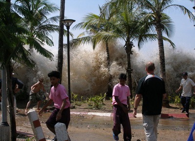
Death and destruction on Boxer Day in 2004
The 2004 Indian Ocean Tsunami began at one minute before 8:00 am on sunny and
beautiful morning on December 26. The megathrust earthquake lifted the seabed
and moved it sideways along a 1,600 km (1000 mile) crack in the Earth’s
surface. The Indian Plate slipped beneath the Burma Plate during the 8.3 to 10
minutes that it took for the rocks to fracture along this length of the seabed.
megathrust earthquake
The seabed shifted 15 meters near Banda Aceh
Trillions of tons of rock was moved during the event as well as huge quantities
of water was displaced as the seabed shifted. The 2004 Indian Ocean Tsunami waves were created by the
energy of the event that swept outward along entire length of the rupture. The
maximum slippage was near Banda Aceh where the land slipped about 15 meters
during this megathrust earthquake.
How tsunamis move through the ocean onto land
Waves traveling speed of a jet plane
The waves traveling at about the speed of a jet airplane swept across the Indian Ocean to eleven low lying countries where they brought death and destruction. As the waves reached shallow water they slowed up and the water piled up creating waves that were 15 meters (50 feet) high as they swept ashore. The waves swept inland in places over 2 kilometers (1.2 miles) inland.

Our Earthquakes & Tsunamis book is about great earthquakes primarily around the Pacific Ocean. This fascinating book explains why great earthquakes and tsunamis occur. Myrna Martin
Click for More Information and to Order
Water receded exposing the seabed
Warning signs of a tsunami
The 2004 Indian Ocean Tsunami waves that came ashore in distant lands were sometimes preceded by
the ocean water receding. The receding water exposed the seafloor allowing many
people to wander around taking pictures of the exposed land before the wave hit.
Many children fascinated with the receding water ran out to look at stranded
fish and boats on the sand. Receding water prior to a tsunami coming ashore
often gives people 5 minutes to run to for higher ground.

Tsunami damage in Sri Lanka 2000 miles away from the earthquake's epicenter NOAA
two people who knew the warning signs
People saved by a British student on vacation
A British student vacationing in Thailand knew the warning signs from a geography lesson. She warned her family and other people in the area where they were able to get to higher land before the waves came ashore. Another India man had watched a National Geographic show on tsunamis saw the water receding. He warned his village of the danger and saved his entire village.
How tsunamis are generated
Seafloor uplifted over a large area
The 2004 Indian Ocean Tsunami waves were generated by lifting or lowering of the seafloor over a large area
of the ocean floor. Tsunamis are generated by powerful megathrust earthquakes
when one tectonic plate slips beneath another plate.
Lituya Bay, Alaska tsunami
Landslides that crash
into bays can create some of the largest tsunami waves in a local area. A
landslide in Lituya Bay, Alaska on July 9, 1958 occurred when an 8.3 earthquake
triggered a landslide that crashed into Lituya Bay. The height of the wave was
516 meters (1,720 feet) high. It was the highest megatsunami ever recorded. The
largest earthquake-generated tsunami in recorded history was 33 meters (108
ft.) tall.
Moment magnitude measurement
Measuring great earthquakes in subduction zones
Scientists use the moment magnitude scale (Mw) to measure very large earthquakes. They use this scale because it takes in the size as well as the magnitude of the earthquake. Various experts have determined the 2004 Indian Ocean Tsunami waves were generated by an earthquake that measured between 9.0 and 9.3 on the moment magnitude scale.
The earthquake released more energy than all the bombs in WWII.
The USGS uses the number 9.1 Mw and recent research by a Cal Tech scientist believes it should be 9.2 Mw. It was the third largest earthquake ever recorded. It released more energy that all the bombs in WWII including the two atomic bombs dropped in Japan.
KIDS FUN Science Bookstore


Check out Myrna Martin's award winning textbooks, e-books, videos and rock sets. The Kids Fun Science Bookstore covers a wide range of earth science topics. Click here to browse.


