What are Normal Faults?
How normal faults are created
Thinning and stretching of the continental crust
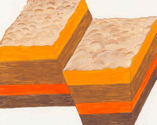
Normal faults develop in areas where the land is
becoming thinner and stretching as forces within the Earth pulls the land
apart. Tension in the crust increases until the rocks break. One block of land
slips downward in relation to the other block of land. A fault plane separates
the fault blocks.
African Plate in the future will become two plates
Parallel faults create grabens, which are flat valley floors, between two parallel faults. The East African Rift Zone has many grabens that formed where the land is thinning on the African Plate. The African Plate in the future will become two tectonic plates that will be known as the Somali Plate and the Nubian Plate.
Normal fault with the fault blocks on the right dropping downward Myrna Martin
Footwalls and hanging walls
Footwall where miners find mineral deposits
A normal fault will have a hanging wall and a footwall. The term footwall is derived from miners finding mineral deposits where inactive faults have been "filled in" with mineral deposits at their feet.
Hanging wall is where the ore is eroding out of the rocks
The hanging wall is the side of the fault above the fault plane where the ore deposit is located. When the ore erodes off the hanging wall it falls down onto the ground of the footwall where the miners were standing.

Click for More Information and to Order
East Africa rift valley
East African Rift System
The East African Rift System is a zone of active
volcanoes and faults. The faults have created a series of rift valleys in
Eastern Africa. The faulting extends more than 3000 km (1865 miles) from
Ethiopia in the north to Zambezi in the south. The African Plate is in the
process of splitting apart in this area forming many grabens.
Grabens
Parallel faults can develop when land is pulling apart. The block of land in between the two parallel faults drops down creating a valley. Grabens are valleys that develop between these parallel faults. The name graben is a German word for grave.
Land dropping below sea level
The area where the grabens are located contain many lakes with lake bottoms below sea level. Lake Tanganyika is located in the area and is the second largest freshwater lake on Earth. It is possible the area may someday become an ocean if the African Plate continues to split apart.
Basin and Range Provinces
Africa, Mexico and the United States have Basin and Range areas
Basin and Range areas in Africa, Mexico and the United
States are examples of places where the continental crust is thinning. The land
is pulling apart in some areas and other areas it is shortening. The result is
a series of mountain ranges separated by rift valleys.
The Basin and Range Province in North America
The Basin and Range Province is a vast inland region of the United States and Mexico. The continental crust is stretching creating mountain chains and flat valleys in the region. The region has stretched up to 100% of its original width.
Hiking the Basin and Range Province North America
The stretching of the continental crust has created unique areas for hikers. Hikers have steep trails that go up the mountains that alternated with long hikes across flat valley floors. People can travel through this area from California or Utah to the state of Sonora in Mexico.
KIDS FUN Science Bookstore


Check out Myrna Martin's award winning textbooks, e-books, videos and rock sets. The Kids Fun Science Bookstore covers a wide range of earth science topics. Click here to browse.


