Tectonic Plate Boundaries
Earthquake patterns reveal size of crustal plates
Seismographs used to determine edges of the tectonic plates
Tectonic plate boundaries have been discovered using seismographs. Scientists discovered crustal plates because numerous earthquakes occur as plates move around and the rocks break.
Seismic waves
P waves and s waves are created by large and small earthquakes as the tectonic plates move around on the Earth's surface showing the outline of crustal plates when scientists plot the location of the earthquakes.
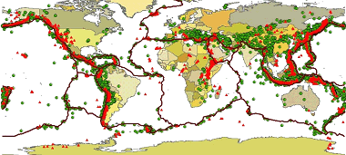
Tectonic plate boundaries, USGS
Divergent plate boundaries
Divergent plate boundaries
A divergent boundary forms where plates are separating. Deep in the oceans at spreading ridges lava flows out on the ocean floor in rift valleys. The basalt lava is derived from melted rock in the upper mantle that collects in pockets called magma chambers.
Global mid-ocean ridge system
The mountain chain that has formed at divergent plate boundaries is the global mid-ocean ridge system. It is the longest mountain chain on Earth. The lava flowing out of the rift valleys forms new oceanic crust. This is the newest land on the Earth's surface.
Mid-Atlantic Ridge
The Mid Atlantic Ridge is a divergent boundary that runs from the North Atlantic to the South Atlantic Ocean. It is about 10,000 miles (16,000 km) long and runs through the Iceland.

Click for More Information and to Order
Convergent Plate boundaries
Collision plate boundaries
There are two types of convergent plate boundaries. Collision boundaries are areas where two continental plates collide. Continental plates smash together forming great mountain chains like the Himalaya Mountains. The continental crust thickens at these tectonic plate boundaries.
Subduction zones
Subduction zones are places where two plates collide. At least one of the plates is an ocean crust. Oceanic crust is heavier and denser than continental crust. When these two types of crust collide the heavier denser oceanic crust is forced downward into the crust and upper mantle where it melts and the rocks are recycled.
Creation of a transform fault
Transform fault boundaries
Two tectonic plates can slip past each other horizontally. This type of movement creates a transform fault. The San Andreas Fault is a transform fault. It runs from the Mendocino Triangle in the North to the East Pacific Rise in the south. The San Andreas Fault separates the North American Plate and the Pacific Plate. The fault if 810 miles (1300 km) long.
KIDS FUN Science Bookstore
Check out Myrna Martin's award winning textbooks, e-books, videos and rock sets. The Kids Fun Science Bookstore covers a wide range of earth science topics. Click here to browse.


