What is a Transform Boundary?
Transform fault and plate boundaries
Fault zone of a transform boundary
A transform boundary is a fault zone where two plates slide past each other horizontally. Most transform faults are found in the ocean where they offset spreading ridges creating a zigzag pattern between the plates. Look at the Antarctic Plate in the map below. The zigzag lines are transform fault zones on the seafloor.
Transform plate boundary
Some transform faults form when two plates slide past each other horizontally forming a transform plate boundary. The most famous transform fault plate boundary is the San Andreas Fault which connects the East Pacific Rise and the Juan de Fuca Plate. The fault separates the North American Plate and the Pacific Plate.
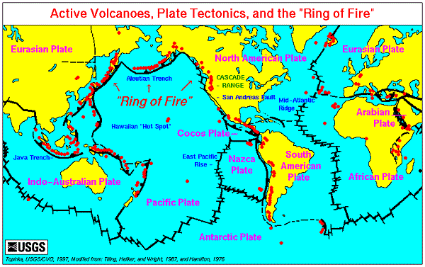
Earth's plate tectonic boundaries and the Pacific Ocean Ring of Fire
Two plates slipping past each other
Plate movement along the fault
Plates separated by a transform fault do not glide past each other. Friction in the rocks causes the plates to lock. The strain in the rocks slowly increases until they fracture. The sudden release of energy is what we feel during an earthquake.
Transform fault movement
The breaking rocks allow the plates to slip past each other. Transform faults are either right-lateral or left-lateral strike-slip faults. When you look across the fault to the other side if the streams and trees seem to have moved to the right then it is a right-lateral strike-slip fault.

Click for More Information and to Order
San Andreas fault overdue for a major quake
San Andreas Fault
The San Andreas Fault is the transform boundary between the North American Plate and the Pacific Plate. During the 1906 San Francisco earthquake the northern section of the San Andreas Fault slipped northward along the fault from San Juan Bautista to Cape Mendocino, a total of 477 km (296 miles).
Central section of the fault
The central section of the San Andreas Fault had a series of large earthquakes in 1857 devastating the region. Now scientists are watching the southern section because strain in the rocks has been building up for over 300 years. In 2005 one scientists said that pressure continues to build in the southern section and the possibility large earthquake could be triggered at anytime.
Richter scale created to study San Andreas Fault
Richer magnitude scale
The fault boundaries on land are associated with frequent earthquakes. Small movement along the fault can trigger deadly earthquakes with large populations. Charles Richter in 1935 devised the Richter magnitude scale to measure earthquakes along the San Andreas Fault. Today, this scale is often used to describe earthquakes medium size earthquakes.
Swarm of earthquakes during June 2019
One scientist with the USGS said we know there will be a large earthquake. We just do not know when it will occur. In June 2019 there were over 1000 smaller earthquakes in a 3 week period. This is not unusual in California and seismologist were not worried about the earthquakes being a precursor for the "big one."
KIDS FUN Science Bookstore
Check out Myrna Martin's award winning textbooks, e-books, videos and rock sets. The Kids Fun Science Bookstore covers a wide range of earth science topics. Click here to browse.


